
QLandkarte GT
Source (link to git-repo or to original if based on someone elses unmodified work):
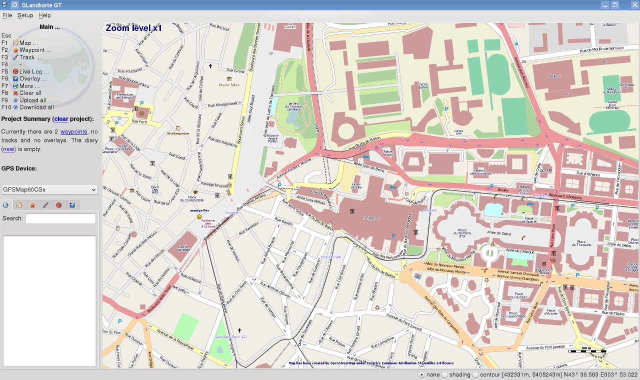
QLandkarte GT does replace the original QLandkarte with a much more flexible architecture. It's not limited to a map format or device. Thus if you think your Magellan GPS or other should be supported, join the team.
Additionally it is a front end to the GDAL tools, to make georeferencing scanned maps feasible for the normal user. Compared to similar tools like QGis, it's target users are more on the consumer side than on the scientific one. QLandkarte GT might not let you select every possible feature of the GDAL tools, but it will simplify their use to the demands of most users.
--- 2011.07.11 ---
Request #297:
Add import/export for OZI data.
Request #298:
Add track profiles to diary
Request #299:
Add import of WBT201 data
Bug #300:
Diary: comments do not match their items
Request #301:
Add option for southern hemisphere in projection wizzard
Request #302:
Enhance coordinate / pixel query on canvas
Request #303:
Iterate over reference points with n and b key for finetunig
Request #304:
Add overview levels to reference process
Request #305:
Add on-the-fly quadratic zoom option to qmap
Request #306:
Add cachename to geocaches on the map
Request #307:
Add selection of multiple waypoints via checkboxes
Request #308:
Enhance delete, icon and proximity funtions for new waypoint selection
Request #309:
Show track point under cursor in profile preview and vice versa






Ratings & Comments
19 Comments
Have packaged your app for Chakra Linux: http://www.chakra-project.org/packages/index.php?act=search&searchpattern=qlandkartegt Maybe you can add it to the list ;)
Hi, I'd like to know if this app is able to read a map (for example a scan of a real paper map) and extract a GPS map. Is this possible? If not, do you know of a software that could do this? Thanks!
Not sure what you mean with "GPS map". If you mean a vector map QLGT can't do. Have a look at GPSMapEdit or Mapwell.
mmh, thanks, I'll do.
Wouldn't be the time for a dedicated repository? I think this usefull tool would be more widely spreaded and used over the GNU/Linux community. Compiling from sources may be a pain fo an average user and grabbing it (e.g.) from Debian repository it's still a nightmare due to dependencies. My 2 cents.
My personal view on binaries is that they are part of the different distributions. Thus it's up to the distribution maintainers to create installation packages that obey all necessary dependencies. I spend enough time on maintaining and developing the source. It's out of my timetable's focus to play around with the different distribution services. This has to be done by those knowing how to do it right. Thus if you feel QLandkarte GT has to be part of a PPA system go ahead and maintain it. If that invokes patches to make it work, feel free to send them. I supported and will support every package maintainer. Oliver
Hi, looks like a nice app yet i currently cannot use it. Does it support csv et kml files? Cycling websites I usually refer to use those formats. Regards,
Yes, KML is supported via gpsbabel. Oliver
Sorry for the noob question, it is the request #93. I will try it as soon as I get a new linux box! Thanks
Hi. I've downloaded, compiled and installed the latest qlandkartegt version but after launching it, it crashes immediately. Google helped me in findig the source of the problem: a bug in gdal 1.5.5-2. Unlucky my attempts in compiling an updated gdal version failed so I ask if there's any safe repository with such updated library available somewhere. I'm using Kubuntu 8.10 with KDE4.2 beta2. Thank you very much.
Nevermind: Google helped me again in finding an useful link in Launchpad.
It can be installed only in special cases on Windows, only on computers with internet connection and without installed Qt4. I have an installed Qt4, and your application cannot find it, but it is in the path. I really do not want to reinstall my Qt4, because I use it in that format. I copied the executable into the Qt4 binary directory, but an error message appeared: the entering point of the process cannot be found... On linux, much more information need for the compilation: gcc, qt4 version, dependencies...
You just have to install QLandkarte on Windows as recommended. It will copy it's own version of QT into it's application path and use it. Your other QT version will not be touched at all. If you do not have an internet connection you can install FWTools from any other source and deselect it during QLandkarte installation. The current binary uses FWTools 2.1.0. Don't know if newer versions are binary compatible. Sometimes the binary path of FWTools is not added to PATH. You will notice if it asks for gdal_fw.dll. You have to do it manually in this case. Don't know why. If you want to compile on Linux it's always a good sport to visit the homepage. http://www.qlandkarte.org will tell you all dependencies and give you instructions. Any recent version of the dependencies will be fine. Most distros do a bad job for GDAL and Proj4. You better install them from source. Oliver
I have not any problem with FWTools. I have not an internet connection on that computer, so qt4 also cannot be downloaded. "It will copy it's own version of QT into it's application path" How can I create it manually? (What is the directory/file structure?) I cannot find instructions for compilation on linux on http://www.qlandkarte.org.
All libraries, except those of FWTools come with the binary package. If you have FWTools installed you can un-check it to skip internet download. For the rest keep the default and do the installation. To compile on Linux read: http://www.qlandkarte.org/index.php?option=com_content&view=article&id=2&Itemid=3 http://www.qlandkarte.org/index.php?option=com_content&view=article&id=3&Itemid=4
hi just to know if I can use this app to manage garmin maps on my n95. Thanks a lot.
I doubt it. The GUI of QLandkarte GT will not fit on a mobile device. That's what QLandkarte M is for. But M is geotiff only.
oh yeah, off course. I meant by using a laptop browsing on garmin map or something like that. Thanks again.
You probably have to write some code to get live position from the n95. There is a NMEA plugin in the Garmin driver collection. But it's not 100% bug free. For my BT GPS it works. For others it won't. But it shouldn't be too much of a problem the write a small interface to gpsd or similar.