
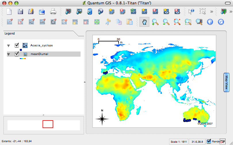
Quantum GIS
Source (link to git-repo or to original if based on someone elses unmodified work):
* For general enquiries subscribe to our users mailing list at http://lists.qgis.org/cgi-bin/mailman/listinfo/qgis-user
* For developer related enquiries subscribe to our separate developers list at http://lists.qgis.org/cgi-bin/mailman/listinfo/qgis-developer
* If you think you have found a bug, please report it using our bug tracker. When reporting bugs, please include some contact information in case we need help with replicating your issue at https://svn.qgis.org/trac
r6350 In Makefile.am added missing headers and EXTRA_DIST files needed for make release
Removed unused Makefile generation from configure.in
Changed version to 'Titan'
r6352 Version 0.8.0 release branch
r6353 Added forgotten docs (who reads them anyway?)
r6354 Fix a bug in Makefile that prevented the gps plugin from compiling
from a clean checkout.
r6356 Updated user guide authors.
Minor tweaks to makefile.am(s) to support make release.
r6359 ported r6358 from trunk (fix for ticket #475)
r6360 Fix for i18n at gdal metadata
r6361 Fix for bug #6277 (man pages not appearing in grass). Also ordered inlcudes alphabteically and removed duplicates.
r6363 Fixing reading projections when opening project file.
1) Default project projections is now set from XML only, and does not get
reset from any layers added.
2) Raster layers get the source SRS from XML only, and does not read the
GDAL view of projection.
Also added som debug outputs
r6365 Polished (changed) how segment lengths appear in the (excellent) measure tool.
The current segment length is shown/updated in the list of segments. Area measurement
is not affected.
r6367 Fix for ticket #478/479. Changed number of decimals in writing world file and points-file
r6369 Merge r6357 from head to 0.8 release branch
r6370 i18n fix filename
r6372 Improvement to zoom-in speed for rasters.
r6374 Copy userguide and index.html to release dir when building under win
r6377 Fix for Ticket #469 (WinQGIS: Cannot load gpx files)
r6378 Copy the resource sqlite3 databases into release dir on build
r6379 Copy the context help files into release dir resources dir on build (qmake)
r6380 Set version to 0.8 Titan instead of 0.8 rc1
r6382 fix typo
r6385 Two errors fixed in georef plugin:
1) Iterator/delete bug
2) Now setting sourceSRS to the same as destSRS after adding the layer into
georef plugin window, which now disables any transformation of the raster.
r6387 Fix for ticket #500 (enable i18n for the mapserver export tool)
r6389 Translation of some context help
r6391 Fix for ticket #186 (spit fails to import some shapefiles).
Fixed a malformed SQL insert statement when attribute data was null.
Plus:
- Improved user visible error reporting when sql statements go
wrong
- Moved some std::cerr debug statements to QgsLogger
- Removed some redundant std::cerr statements
- Fixed several memory leaks from uncleared Postgres queries
- Fixed 'loading twice' bug when layers are selected in the table
- Improved code layout (more blank lines)
r6393 Fix for ticket #288 (transparent images aren't drawn with transparency).
r6396 Improve line/area measuring behaviour when the user has been informed that
they are probably using the wrong projection for the map canvas
r6409 Ported r6405:6406 from refactor branch
r6437 Add QtSql framework to Mac library list. Qt3Support needs it but it isn't loaded automatically by the Qt4.2.2/Mac binary distribution.
r6438 Make Add Attribute dialog modal and set parent for all dialogs in chain. This fixes incorrect layering of stacked dialogs on Mac (bug #509).
r6444 wfs fix also for the 0.8 branch
r6445 !enddif tag has been commented to get uncompression of sample data working.
r6456 Decompression of Alaska sample data reactivated
r6458 Fix for ticket 549: groups lost and all layers expanded, if layers missing opening the project
r6469 Removed ISO C++ ambiguity
r6470 CMake files for 0.8 for easier debugging. Only tested on Linux so far.
Does NOT create the same libraries as Makefiles.
Normal Makefiles not affected.
r6478 Fix for #546, too low precsision in GPX create layer. Also fixed some compiler wanrnings.
r6483 This should fix missing query builder buttons (#252).
I've deleted the old buttons and recreated them - Luca has confirmed that
the problem dissapears.
r6485 Added Brendan
r6487 Fixed formatting
r6502 Applied patch from ticket #565 Do not render features or their labels if their classification value doesn't match a symbol's lower/upper range
r6506 Fixed CMake files for 0.8 built on win32. Does not build wms, and postgres is not tested/does not work.
All qgis files are compiled into qgis_core.dll (raster, legend, composer, gui, core).
Resulting binary crashes, but runs in gdb. Beware!
Please see build instructions for trunk on win32, the same environment is used here.
r6508 Small fix for postgres headers
r6509 Fixes bug #523 and #560. Unintialized variables in georeferencer.
r6511 Fix for bug #538 Malformed line crashed delimited text provider.
r6517 Ported r6515 to 0.8
r6518 Now compiles wms and postgres with CMake
r6521 Fix CMake search for libraries
r6529 Latvian translation updates from Maris Nartiss
r6530 CMake now install grass files
r6537 Merged r6535 and r6467 into 0.8
r6538 Ported r6536 to 0.8
r6542 Fix include paths for 0.8
r6543 Adding build notes for CMake and 0.8
r6544 CMake adjusted for WMS/Postgres both on Win32 and Unix
r6545 Updated CMake 0.8 on win32
r6550 Fix for Mac window title and controls corruption which was caused by an integer overflow when calculating an empty panning rectangle. (same as r6471 in trunk)
r6551 Use variable name from current loop rather than previous loop. Correction to r6502.
r6554 Added missing GEOS include path for building pg provider on mac
r6574 On Mac, search for util.h instead of pty.h (same as r6525 in trunk)
r6575 CMake tweaks to get build working on mac
r6576 Added missing inlcudes and libs for mac build to work
r6577 Added missing inlcudes and libs for mac build to work
r6578 Added missing inlcudes and libs for mac build to work
r6579 Added missing inlcudes and libs for mac build to work
r6580 Added missing inlcudes and libs for mac build to work
r6581 Added missing inlcudes and libs for mac build to work
r6582 Added missing inlcudes and libs for mac build to work
r6583 Added missing inlcudes and libs for mac build to work
r6584 Added missing inlcudes and libs for mac build to work
r6585 Added missing inlcudes and libs for mac build to work
r6586 Added missing inlcudes and libs for mac build to work
r6587 Added missing inlcudes and libs for mac build to work
r6588 Added uninstall target for cmake
r6594 I took the liberty...
r6598 Fix for bug #574. Checking for out-of-memory when allocating data buffer for rasterIO,
and also trying to avoid too high zoom level. In either case, the raster does not get displayed.
r6601 Fixing tabs
r6604 No double warning in case snapping failed (for 0.8 branch this time)
r6605 Added better logic for application path:
We could just hard code the path to qgis libs and share dir (as used to be done)
but that makes qgis non relocatable which is needed for my
generic QGIS linux bundle. So lets start by trying a relative path
and then falling back to the paths set in the make process
r6606 Fix for bug #569
r6614 Fix for #599 also for 0.8 branch
r6617 Applied patch #603. Thanks!
r6631 Use absolute file path to util.h on mac to resolve compile errors due to geos util.h being found instead
r6632 Install mac bundle stuff
r6633 Hard code search path for util.h on mac
r6634 Adjusted the version to have no spaces and to be ready for 0.8.1 release. Having spaces in the version breaks some sed scripts that run when doing a make install on osx.
r6635 Added tooltips to the scale and coordinate position displays
in the status bar.
r6638 Fix for compiling with cmake and without postgres
r6639 Updated version 0.8.1
r6641 Updated version in spalsh to 0.8.1
r6645 Set version no to 0.8.1
r6646 Dont build unit tests
r6647 Install headers for 0.8.1 into $PREFIX/include/qgis so that 3rd party app writers done need qgis sources
r6649 Dont try to run moc on qgsproject.h which is not moccable
r6650 Add qt plugins to the setup file
Add includes to the setup file (in its own section)
r6659 Backported change from 6658 to 0.8 brnach (dont overwrite qgssvnversion.h with each build)
r6660 Small fix to qgssvnversion detection
r6662 Backported from head to fix build problems in win cmd.exe prompt
r6667 Enhancements to installer builder:
- added a new zipdll.nsh that needs to be copied into the NSIS/include dir and should fix download and extract sample data functionality
- updated readme file
- it now expects the qgis binaries to be packaged to exist in c:\Program Files\qgis
- set the PRODUCT_VERSION_NUMBER before running
This will allow having multiple development versions on the same machine and being able to package them without issue.
r6668 More helpful hints and germane advice for wannabe nsis users
r6669 Make the generated setup exe automatically contain the version number e.g. qgis_setup0.8.1.exe
r6670 Im no longer supporting / maintaining two versions of teh installer. If we want debug stuff in the future Ill add it as a new section in the installer.
r6673 Fixed qgssvnversion.h generation on Linux, Cygwin, cmd.exe and hopefully also on Mac
r6676 Remove ugly console on WIN32 when not debugging
r6678 Updated SPONSORS for 0.8.1 release
r6680 Fixed qgssvnversion.h dependency
r6681 Made some more fixed paths relative
r6683 Part fix for bug #530 - add plugins/ dir to qt plugin search path
r6686 Setting runpath for locating dynamic libraries in the installation directory
r6688 Re-added fix for generating .h
r6690 Added mongolian translation
r6691 Updating swedish translation.
r6693 Some more swedish help translations
r6694 Some minor spelling corrections
r6695 Fixed search paths for application data
r6697 Context help are always in UTF-8, so on Win32 we need to convert the files when loading.
r6698 Fixed spacing
r6700 NO SIDE EFFECTS IN ASSERT() ! (see man assert for more info)
r6701 Applied patch from ticket #615 to use appropriate search path for help files
r6702 Added notes for unattended install and customising installer
r6704 Make installing the application section mandatory
r6706 In progress : work to make exe show qgis icon properly
r6707 Renamed ico file to qgis.ico
r6708 Placeholder new icon - last was corrupted
r6709 Fixed issue with icon not showing on application
Using a placeholder Q icon for now
r6713 Dont install sample data by default since it requires a net connection
r6714 fixed booboo with section numbering
r6715 Fixed building msexport with runpath
r6716 Fixed Makefile.am for helpviewer
r6718 update of german translation by Stephan Holl, enable create spatial index only for providers where this is supported
r6723 Fixed pkgDataPath to docs
r6734 Set path to windres.exe
r6736 Fixed bug #507 - query builder code was commented out due to issues with the old (non cmake) build system
r6737 Changed copyright default year
r6738 Made Copyright text take current year as default.
r6742 added wait cursor during inital load of grass toolbox
r6755 Partial fix for bug #632 (size too large error).
r6762 Changed identify tool to query each WMS layer separately, instead of sending a long list to the server. This should fix part of #632.
r6763 Fixed memory leaks in raster drawing
r6770 Icons for grass mapset and layer tools
r6771 added icons to all grass tools; all grass tools now on the toolbar
r6781 Pathc for plural forms added. Thank you lubaby
r6782 Fix for #519. All values written to map file are now encoded with utf-8, to prevent Python exception
r6789 Merge of r6788 from head to 0.8 branch
r6794 Ignoring color ramps from 0.0 to 0.0 to be able to draw malformed TIFFs. Fixes #643
r6795 removed old qmake instructions and other tidy ups
r6800 Fix for ticket #651 (zoom to full extent doesn't work for a single point
layer)
r6801 GRASS modules from Leonardo Lami and Massimo DiStefano
r6802 Launcher plugin added to core plugins to boost gsherman's karma
r6803 Reverted r6801 (new grass modules) due to problems:
1. Some modules are not working properly (missed during testing)
2. Mac OS X was unable to checkout r6801 due to unknown reasons
r6804 GRASS modules from Leonardo Lami and Massimo DiStefano
r6805 Fix launcher plugin load/unload
r6806 UI tweaks to make Tim happier
Command list saved to user settings
Clear command list button added
Removed some dead code
r6807 Don't add repeated commands to the launcher history list
r6808 Added module name to the module tab in the GRASS toolbox (Ticket #596)
r6809 Removed unused declaration
r6816 Added i18n patch #666...
r6817 Applied i18n patch in #667. Thanks!
r6818 Backport for measuring from trunk to 0.8. Not everything is ported, but the main functionality should at least be correct.
r6819 Small fix to make r6818 compile on win
r6822 More swedish translations.
r6823 Removed crash in 0.8 when reading project files from 0.9. Also removed compiler warnings
r6827 sqlite3_open() MUST have db name in Utf-8. Fixes #676.
r6835 Applied patch #683 to 0.8.
r6837 Added patch #685 from lubaby (+ some more) to 0.8
r6841 Swedish translations.
r6886 initialize xOffset and yOffset to 0
r6889 Enhanced precision in georef plugin for 0.8.1 version
r6895 Added more header files to make install
r6897 Fix for compiling with python 2.5 (same as r6758 in trunk)
r6912 Make 'legend' font size mac friendly
r6913 Fixed problem caused by committing form with too new version of designer
r6915 Added -c flag to v.out.ogr (ticket # 700)
r6916 Updated version number and changed description of the useless Launcher plugin
r6917 Applied patch from lubaby to fully internationalize the GRASS plugin (ticket #697)
r6925 Ported GRASS version.h workarounds from trunk.
r6932 Ported r6894 to 0.8 branch (workaround for G_set_error_routine)
r6947 Set WMS version to 1.1.1. also for 0.8.1 branch
r6962 CH1903 changes also for bugfix branch
r6975 Fix for ticket #630, thanks to patch from lubaby.
(attribute table drift on windows)
r6983 Fix for ticket 652 also for 0.8.1 branch
r6987 Fix for ticket #652 also for 0.8.1
r6992 added missing libz.dll.1.2.3 file
r6994 Moved to using text2tags for managing install etc docs. Please edit the install docs here (not on the wiki!) and then use txt2tags to generate moinmoin output and paste into the wiki. Also do not directly edit INSTALL but rather edit INSTALL.t2t and regenerate teh INSTALL file using t2t plain text generator.
r6996 Removed python related notes for 0.8.x branch
r6998 Added OSX install procedure to install docs
r6999 Updated ts files
r7000 This file is deprecated. See INSTALL.t2t instead
r7001 Updates to compile docs - added linux section and reformatted just about everything :-(
r7002 Fixed some small formatting issues
r7003 Fixed some more formatting glitches
r7004 Updated what's new section for 0.8.1 release
r7005 Quoted names and classes where appropriate
r7006 Added shadowman pic for developers with missing mugshots
r7007 Added shadowman for Peter
r7008 Updated AUTHORS and CONTRIBUTORS
r7009 updated release notes for 0.8.1
r7010 updated release notes for 0.8.1
r7011 Yet another change to the release notes
r7012 Fixed issue with default toolbar arrangement and loaded lugins list on first run (win only)
r7013 Show warning about grass preferring a path with no spaces. Show readme on last step of installer.
r7014 Aplied patch from ticket #598
r7019 Applied patch #725 which also fixes ticket #698
(This patch fixes crash (ticket #69![]() and also adds some i18n stuff (missing tr(), and encoding conversation where nedded). Included patches for HEAD and also for 0.8.x)
and also adds some i18n stuff (missing tr(), and encoding conversation where nedded). Included patches for HEAD and also for 0.8.x)
r7020 Added version numbers of grass and related libs used for win build
r7021 Tidy up win lib version numbers a bit
r7023 Backported find rules for pg and gdal from trunk
r7024 Updated Slovak translation as per #727
r7025 Applied patch from #728
r7030 Fixed a bug in win installer causing the install step to run twice
r7031 Set qgis release name in main.cpp
Set qgis version in configure for those using auto*
r7032 Autotools build update:
Check for Qt 4.2 or higher rather then just 4.2.
Add launcher plugin.
r7033 Autotools build update: another file for launcher plugin.








Ratings & Comments
1 Comment
10 10 the best